
Our Services
Precision Surveys provides a wide variety of services for a diverse client base. Our
expertise enables us to provide services and support functions for home owners, developers, realtors, municipalities, title
companies, attorneys, contractors as well as other engineering companies. The following represent a few of the services we offer.
FEMA Elevation Certificates - Commercial and Residential
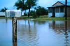
If your home or business is located in a flood hazard zone, it is often advantageous to have a FEMA Elevation Certificate prepared. The preparation and submission of an Elevation Certificate provides the folks at the National Flood Insurance Program (NFIP) and FEMA with real data that can often result in a significant reduction in your premiums.

Boundary Surveys and Dispute Resolution
What happens if someone is building a structure, erecting a fence or even landscaping on your property? The physical location of your property lines is critically important to your residential or commercial land development project or improvement. Maybe your neighbor has erected a fence on your property. There are many reasons to request a boundary survey or discuss important boundary matters with a professional land surveyor.

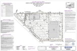
Site and Permit Plan Preparation
Precision has experts standing by to schedule your survey and prepare your site plan or building permit plan for your project. If you are planning to improve your property, we can assist you by preparing the plans required to retrieve permits for your project. Our plans are based on REAL field surveys!

Topographic Mapping - Existing Conditions Plans
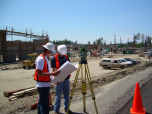
The accurate location of physical features, vegetation and surface elevations are critical to the successful design and construction of any project, commercial OR residential. Precision survey crews use myriad state-of-the-art equipment to efficiently locate buildings and/or structures, utilities, paved areas, ditches, vegetation and other physical features through the use of on-board and off-board data collectors.
Construction Layout - As-Built Documentation
Every aspect of a construction project must be timed appropriately and our crews will keep your schedule moving. Our field surveys are well-versed and trained in the needs of our clients and know their way around a construction site. We have many clients that use Precision exclusively for construction and building layout.
ALTA/NSPS Land Title Surveys
Precision Surveys performs ALTA/ACSM Land Title Surveys for a wide variety of clients to include national entities, developers, lending institutions, attorneys and property management companies. We offer full-service assistance with regard to the survey aspects of the closing process. Our surveyors will work directly with your lending institution and title folks to ensure your survey is prepared for settlement.
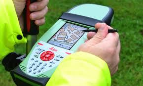
GIS Data Collection and Geodatabase Submissions
Precision is well-versed in the collection of GIS-related field data! We use state-of-the-art survey equipment, plan project-specific collection efforts, capture and geo-tag images, provide for quality control and develop complete submission packages for our client based on their specific needs. Our locations typically meet survey-grade accuracies as our established workflows have allowed for survey-grade collection without effect on costs.
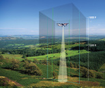
Aerial Mapping, LiDAR and Drone Services
Aerial surveys and imaging are exceptional tools for acquiring mapping for design, construction, geographic information systems and asset management. The Precision team is capable of producing mapping for any size project and can integrate conventional locations as needed in order to develop a complete mapping project. As accuracy levels increase, this approach has gained popularity among our clients both in terms of efficiency and costs.

Subdivision Design
Our team at Precision can assist you with preparation of entitlement documentation for commercal and residential development projects as well as permitting and site plan preparation for your personal project. We are experts in navigating state and local requirements necessary to making your project meet with a successful and timely completion.
Would you like to discuss your specific needs?
Please contact us at +1 410-459-2124 +1 410-459-2124.
Questions?
We look forward to talking with you about your project.
Precision Survey and Mapping LLC
Phone: +1 410-459-2124 +1 410-459-2124
Email:
Or use our contact form - Be sure to include the address of the property.
Portfolio
Take a look at our recently completed projects to get a better idea of our capabilities and performance quality.