
FEMA Elevation Certifcates and LOMA submissions

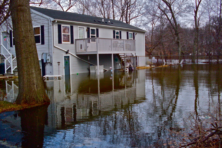
If your home is located in a flood hazard zone, it is often advantageous to have an Elevation Certificate prepared. Currently, FEMA and NFIP use approximate mapping to establish the elevations associated with your home and property with regard to established flood elevations. Without accurate survey data insurance adjusters must consider the worst-case scenario when evaluating the liability and establish your rates accordingly. These decisions are often made without the benefit of accurate survey data, which would identify real elevations for your home, surrounding ground surfaces and even the mechanical and electrical components in your house.
The survey measurements and data collected for submission on your elevation certificate will determine your flood insurance rates for the next many years. It is important to get this done properly and to consider a surveyor with the most flood-related experience. This is not always the cheapest fee... not all surveyors are equal in their knowledge of the process or understand what is important to NFIP in developing yinsurance rating flood openings or making small adjustments that might be of benefit.our rate.
To order your FEMA Elevation Certificate, Call 410-459-2124 today or send a message to our surveyor at chuck@precisionsurveys.us. Be sure to include your address so we can provide you with a free estimate to prepare the Certificate.
Precision Surveying and Mapping LLC has the experience to prepare your certificate with the insurance adjusters in mind. We also have a 100% success rate for qualified LOMA submissions! We perform actual field measurements using state-of-the-art surveying instruments and techniques in order to determine the property’s elevation and other relevant data. The data is reviewed and transferred into the appropriate format on the Elevation Certification documents. Your Certificate will be signed and sealed by a Professional Land Surveyor registered in your State. Precision also has an ongoing professional relationship with FEMA that allows for stream-lined methods to support requests for Letter of Map Amendments (LOMA) or Letter of Map Revisions based on Fill (LOMR-F).
Precision also has considerable success with the preparation of LOMA's and LOMR's submissions. These are Letters of Map Amendement and Letters of Map Revision recognized by FEMA. Should it be determined that your property or structures are higher than the base flood elevation you may qualify for an exemption. Your surveyor of choice should be able to navigate this sytem and prepare the appropriate documents. Precision surveyors are experts in these submissions.
Why should you order an Elevation Certificate?
An Elevation Certificate represents real survey data measured by a licensed surveyor. The preparation and submission of an Elevation Certificate provides the estimators at the National Flood Insurance Program (NFIP) and FEMA with real data that can often result in a significant reduction in your premiums, often offsetting the cost of the Certification. At minimum, the home-owner will acquire the confident that their investments are adequately insured.
How is my flood exposure determined?
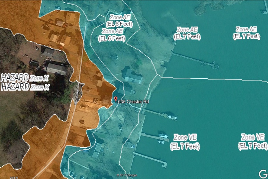
Currently, FEMA and NFIP use approximate mapping to establish the elevations associated with your home and property with regard to established flood elevations. They use a combination of LiDAR (Light Detection and Ranging) photogrammetry in conjunction with flood studies generated by local municipalities and engineering companies. With this data, FEMA is able to assess flood hazard areas and usually generate a BFE or base flood elevation. Although LiDAR typically generates an accurate model, there ares til some innaccuracies involved. The most obvious of which would be tree cover.
Using hydraulic calculations and exisitng mapping, FEMA essentially make an educated guess concerning the flood liability associated your property based on flood studies and elevations established by previous flood situations... then establish your rates accordingly. These decisions are made without the benefit of accurate survey data, which would identify real elevations for your home, surrounding ground surfaces and even the mechanical and electrical components in your house. At minimum, the home-owner will acquire the confidence that their investments are adequately insured.
Can I Remove My Home From the Mapped Flood Hazard Area?
In some cases, the survey indicates the lowest adjacent grade for the property or structures do not fall within a documented flood hazard area. In this case, an experienced surveyor can prepare a submission to FEMA known as a LOMA (Letter of Map Amedment) or Letter of Map Revisions based on Fill (LOMR-F) which enables FEMA to administratively remove the structure or property from the hazard area. In this case, a homeowner or business owner may be able to eliminate the mandated requirement for flood insurance. Precision still recommends protecting your property if it lies within the vicinity of a documented flood hazard area. Under this circumstance the rates are tyically reduced to the point that the coverage makes practical sense. Precision surveyors are experts in these determinations.
To order your FEMA Elevation Certificate, Call 410-459-2124 today or send a message to our surveyor at chuck@precisionsurveys.us. Be sure to include your address so we can provide you with a free estimate to prepare the Certificate.
Questions?
We look forward to talking with you about your project.
Portfolio
Take a look at our recently completed projects to get a better idea of our capabilities and performance quality.